
Historically, cities were built alongside waterways for sustenance. Unfortunately, many urban environments polluted them. Fortunately, the majority of cities rectified that, became eco-friendly, cleaned their messes, and revitalized their waterside landscapes. Shanghai, Frankfurt, Amsterdam, Paris, Porto, Prague, Aswan, Budapest, Nashville, Quebec City, Boston, London, Valparaiso, Cai Be, Stockholm, Florence, Copenhagen, and Rio de Janeiro are great examples. New York City is not.

Despite being the United States' wealthiest city--and the most expensive to reside in--it uncaringly lets its riverside and oceanside properties remain slovenly. The situation has been like that since the Industrial Revolution. Edith Warton's turn-of-the-century novels remarked about the decrepitness. When NYC still had a port, oceangoing travelers/visitors saw gas storage towers, oil refineries, slaughterhouses, and derelict buildings. That remains to this day.


NYC is a waterside city, and Manhattan is an island. Three of its four other boroughs are also on islands. Therefore, you might have a reasonable expectation that its population enjoys splendid waterside views. It might even justify the enormous inflated costs of living in NYC. You are wrong.
Even though it is practically connected to New Jersey, Staten Island was taken by NYC to suck its revenue.

Officially named Richmond County, it was annexed by NYC in 1898 and became a borough. In exchange, NYC used the island as a garbage dumping site and landfill. It became the largest waste site in the world. Generations of environmentalists wailed about the toxicity of things dumped there. Here are images of its history.


When it couldn't hold any more, NYC put grass on it and called it a park. Illegal dumping still occurs (old habits).


People are still concerned about where NYC's garbage is sent. But authorities don't talk about it.

The city also put the nation's most expensive toll bridge there. (For the last century, it neglected to connect the borough with subways; it lets people use windswept ferries). Unlike the ones in Hong Kong, the outdated ferries have not gotten faster in 100 years.

Merely using the island as a "stepping stone" to get people to Manhattan, the greedy city sliced through the island's historic neighborhoods to install highways and bridges. Currently, the island's marshes are adjacent to concealed waste dumps. Half of the waterside property is monopolized by the Sanitation Department, a container-loading dock (which recently suffered from a toxic spill), a Federal Express distribution center, an Amazon distribution center, three Consolidated Edison (ConEd) power generating facilities, waste management facilities, water treatment facilities, lumberyards, petroleum tanks, a salt-making factory, concrete makers, ship repair docks, asphalt makers, auto parts shops, onramps for bridges, and ferry terminals.


Starting in the 1980s, an environmental disaster began when medical waste and sewage spills from the island leaked into the ocean, and the debris washed up on the New Jersey shore. NYC paid a mere $1 million in penalties, but did not reimburse hundreds of shoreline businesses and parks for their lost revenue during that summer's clean-up when the beaches and boardwalks were closed.


Brooklyn is not better. Sustained by its own economic growth, it was originally its own city: the third-most populated in the USA. It fought against being annexed by New York City, but it lost the battle in 1894. Officially named Kings County, Brooklyn became a borough. Half of it steadily deteriorated. Currently (and despite NYC's bloated police force), Brooklyn has a crime rate that is higher than 89% of communities is the USA.
An abandoned airfield became a park. The repair & storage yard of the Metropolitan Transportation Authority abuts Coney Island Creek.


So does a scrap metal facility, and a NYC Sanitation site/dock. Coney Island Beach is dominated by an amusement park that is alongside "urban sprawl".

Aside from a few beaches, two highways cut off the majority of Brooklyn from the water. I guess it didn't make sense for them to put some beachfront beyond the highway. The noise, traffic jams, and auto pollution do not help those communities that are so close to the water.

What did get priority for waterside construction was another massive wastewater treatment plant, a huge railroad yard, a military shipyard, outdated rusty warehouses, gas tanks, another train yard, a gigantic (but disused) cargo shipyard (with dilapidated piers that could be reclaimed as parks), a sand/gravel facility, petroleum facilities, stone cutters, an iron salvage yard, salt pits, parking lots for trucks and buses, concrete makers, scrapyards, a police-controlled automobile impound yard, and a humungous barge/container loading dock. The always-busy highways and curlicue onramps for six bridges take up more space. *Building the Brooklyn Bridge caused the demolition of George Washington's historic home on Manhattan's Cherry Street. Nobody cared to relocate it for preservation.
Equipped with orange smokestacks and boxy Soviet-looking buildings, Five ConEd power plants are situated on the waterfront, and four ConEd sub-stations exist inland.


The Brooklyn Navy Yard has a sizable chunk of real estate, adjacent to the (always labelled as) "up and coming" neighborhood of DUMBO. Sadly, DUMBO is an acronym for Down Under the Manhattan Bridge Overpass, because NYC callously trampled its boroughs when finding ways to feed itself with commuters. Both downtrodden areas are almost the same size. Next to that, Domino Sugar has a big refinery.


Across the bridge is the Department of Sanitation's Special Waste Drop-off Site.
A long stretch of waterside property was commandeered by luxury hi-rise apartment buildings. An abandoned oil storage compound is a blight of rust and corrosion, yet residents are trying to find something to do with it. A series of construction companies occupy waterfront land, as does a gigantic parking lot for trucks. The city managed to squeeze a baseball field between that truck lot and the shadow of a condominium tower. On the other side is another sprawling parking lot for buses, followed by three parking lots for trucks.

Priority was given for dozens of gas companies, oil refineries, petroleum storage tanks, distribution sites, fertilizer factories, and "energy facilities". Instead of enriching their community, they brought a legacy of contamination (which happens with numerous American industries). 50 of those structures were installed in the 1840s and during the Industrial Revolution by the globally-notorious Standard Oil Company (now Exxon-Mobil and owned by the cutthroat robber-baron Rockefeller family).


They line both sides of the Newtown Creek, which is the border between the boroughs of Brooklyn and Queens.


In 1919, 20 acres of the Standard Oil Company's facility were engulfed in flames. The fire raged for 3 days, while flammable and noxious substances burned! Pollution resumed thereafter. Eventually, the fish, clams, and oysters of the area died. Historical documents mention the ungo dly stench that seeped across the county--even into Manhattan. The New York Times reported that commuters on the Long Island Railroad (itself a corrupt monopoly) complained about the horrible odors during their train rides past the area. Despite NYC's bloated government, nothing was done. For 100 years, tax-paying law-abiding citizens and advocate groups complained, protested, and petitioned, but--since this is NYC--their tax-paid, law-breaking politicians did very little to solve the issues.
The area is world-famous for the Greenpoint Oil Spill, one of the largest in American history. But real estate agents won't tell you that. Throughout several decades, crude oil, sludge, and petroleum byproducts were "leaking" into the neighborhood and its river. It's amazing that the wealthiest companies (with the highest profit margins) don't seem to notice ways to be responsible. In 1978, a Coast Guard helicopter noticed the toxic water pollution: 100 acres of spillage. It was 3-times larger than Exxon's Valdez Spill! (Standard Oil became Exxon and Mobil).

Naturally, NYC claims that everything was cleaned up and the area is ready for taxpaying residents to live in and start families. However, recent environmental tests still show positive indications of contamination, and they assert that a majority of the spillage is (logically) retained in the soil and groundwater. None of the greedily-overcharging gas companies were legally blamed for wrongdoing, and no compensation was issued to the hundreds of thousands of homeowners that might suffer from noxious vapor infiltration (like living above an auto body shop or gasoline station). Dozens of oil-producing/storing facilities remain... and--despite a century of evidence of continuous neglect--they "promise" to behave better. However, in 2019, the Brooklyn Eagle newspaper issued a whistleblowing exposé about three oil storage facilities that still discharged acidic oil toxins into the already-polluted river. The state government promised to investigate. Would you like to go swimming or kayaking there?

Adding ugliness, the city uses the area for 19 Waste Transfer Stations! (It has 58). Full of trucks, bulldozers, trains, and barges, those facilities handle 5 million tons of of trash per year. (As the most wasteful city, NYC produces 12 million tons of garbage, rubble, and debris. A lot of it is shipped 7,000 miles to China).

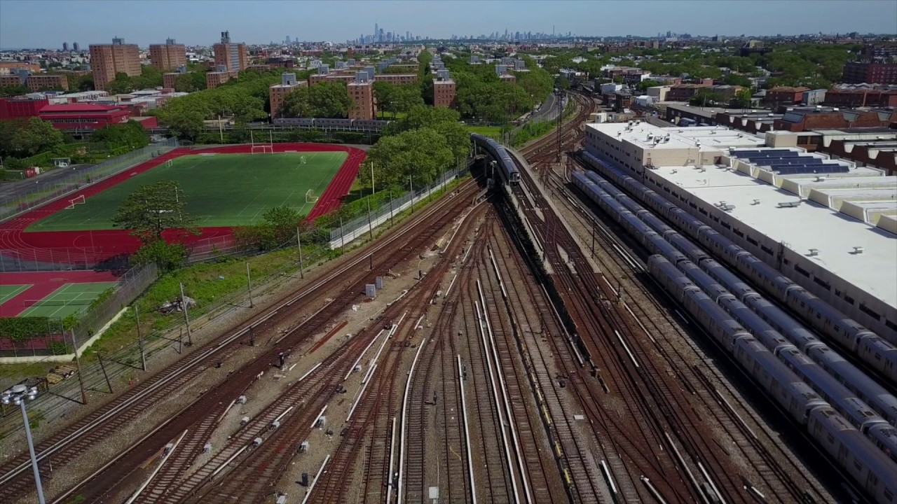
Crossing into Queen County (which NYC annexed in 1897), another sprawling train yard stretches from the waterfront for 2.5 miles inland. Luxury hi-rise apartments are built at the edge of the land, but (naturally in NYC), a congested road sits at the edge of the East River.


More riverside acreage is lost to a glass tempering factory, a taxicab parking lot, neglected warehouses for the NYC Department of Transportation, and another Soviet-looking boxy building for the Department of Education.
The area of Long Island City resembles a fungus of skyscrapers that were needlessly erected because the zoning against tall buildings was changed by mayors to make them possible. Taxpayers are never consulted by their tax-paid politicians for such maneuvers that forever alter their lives; those actions are merely intended to benefit the biggest bribers: real estate and finance. Click this image to make it clearer...

Now, dozens of skyscrapers block sunlight and are a visual blight on the area... forever. Perhaps karmically, they are mostly empty since Amazon rejected LIC as a location for its hub... probably due to NYC's failing infrastructure.
To read more about LIC, please use this link:
https://halfwindsorfullthrottle.blogspot.com/2017/04/long-island-city-grows-because-it-lives.html
Without leaving space for sizable community parks, developers encroached against the shoreline. A tiny sliver is intended to be a "park". Luring tenants, dreamy schematics appear annually of recreational facilities in LIC... but they never materialize.


Instead, LIC residents can expect three consecutive hours of horn-honking during Rush Hour traffic jams via the antiquated Queensboro Bridge: 3 hours in the morning, and 3 at night.


ConEdison consumed one mile of property along the river for its facilities. In the shadow of its smokestacks (and the bridge), a baseball field was installed... overlooking a sprawl of poverty-stricken Public Housing complexes (the largest in America).


Next, we finally see a usable park: 8 acres called Rainey Park. Queens is the most-populated county in the United States, yet it has the least amount of waterfront... despite half of it facing the water. Why? Industries were allowed to take it. A large Costco shopping facility separates the riverfront from Socrates Sculpture Park: a 5-acre park that was previously a landfill. Seen below, for a few hundred feet, there is a sliver of sand. Despite debris, some people use it as a dirty beach (during low tide).

Except for the thin peninsula of The Rockaways, it's the only other "beach" in the whole county (seen in yellow).

Unfortunately, it is strewn with jagged rocks, abandoned pier foundations, and dumped garbage/tires.


Making it less attractive, it is bordered by a the wall of a boulevard, a fenced vehicle storage lot, and two seemingly-vacant warehouses.


A spacious outcropping of the Astoria neighborhood was given to another sprawling Public Housing complex (police sirens and fire engines are there several times per week, and police helicopters hover there, at least twice per month, making enough noise to sound like a war-zone).


The other half of the riverfront property is wastefully consumed by derelict warehouses, a stucco maker, and parking facilities for school buses.


When a luxury hi-rise developer built towers in the area, they city covered some land with another baseball field and called it a park. However, rundown warehouses still pervade most of the area: such is the view from those expensive apartments. They are also adjacent to the Housing Projects (seen as X's in this aerial image).


Across the river, another patch of waterfront is obliterated for the Sanitation Department's Waste Transfer Station. Alas, its never-ending parade of garbage trucks runs parallel to a children's sports field. Taxpayers are upset that their tax dollars (we pay nearly 50% of paychecks to taxes) is a blight on the area.


Sitting under two bridges, Astoria Park gives 60 acres of oasis to Astorians.

Yet, there is no access to the shoreline; you can look down at from the quay. Thanks to trashy New Yorkers, the shore is littered with broken glass. Since the overpaid city does not clean it, local volunteers of taxpayers try to clean it.


The view from the park overlooks Randall's Island, which the city filled with two Psychiatric Asylums, the Triborough Bridge, and a huge wastewater treatment plant.


North of the island, the Bronx waterfront is ruined by four Waste Management Sites, a recycling facility, a demolition company, and railways that haul trash.


Unfortunately, half of Astoria is gobbled up by a massive ConEd power plant. In this image, the park is the green rectangle the lower-left corner. The power plant is 5x as big.


The ConEd facility is alongside a sewage treatment plant, and construction companies. Instead of residents enjoying waterside views, the riverfront is occupied by corporations. The Steinway Piano factory is also there.
Queens lost more waterside acreage to have both of NYC's airports: La Guardia and JFK International. They are two of the worst airports in America--responsible for at least one quarter of all air traffic delays in the USA! They are rundown and neglected. President Biden once remarked that they were more suitable for a third-world country. JFK consumes nearly all of Queens' southern waterfront.


Beyond the thundering noise from jets and aircraft at La Guardia, a congested highway separates the water from Queens residents. The community of College Point occupies another outcropping, but much of its coastal property is consumed with rundown warehouses, a Pepsi Cola bottling plant, a corporate facility for Spectrum Cable & Internet, two marine Waste Transfer Stations, and a wastewater treatment plant. Finally, some beachfront is allowed for upscale Queens residents... who don't mind the nearby Tropicana Juice factory, or the honking horns of cars/trucks along the Whitestone Bridge and Throggs Neck Bridge, or the traffic jams on the Whitestone Expressway and Cross Island Parkway. The busy parkway separates 3 miles (the majority) of Little Neck Bay from the residents in Queens. It then cuts right in the middle of he area's largest park, which is also intersected by the always-congested Long Island Expressway, and the Grand Central Parkway (which is usually under construction). The only sliver of Queens that resisted corporate-sponsored overdevelopment involved communities of the Rockaways. In a passive-aggressive retaliation, NYC maintains a deplorable resistance to upkeep the infrastructure in the Rockaways. Whenever storms strike the coastal communities, they are the last to receive aid.
The borough of The Bronx was annexed by NYC from Westchester County in 1874, and more was taken in 1895. It has the most parkland waterfront and residential waterfront in NYC.


But the other two-thirds of its waterfront is given to parking lots for school buses, a United Parcel Service facility, food warehouses and distribution centers, beer breweries, petroleum storage tanks, railways to FedEx and Fresh Direct processing centers, two sewage treatment plants, sand pits, gravel pits, an island containing prisons/correctional facilities, and a MetroNorth train yard. If that wasn't enough, another expressway separates the rest of the waterfront from its residents. Clearly, NYC never thought that waterfront was worthwhile to use for public enjoyment.
Like most of the boroughs, it was overrun by ugly highways designed only to benefit Manhattan as funnels for commuters.


Off the northeast shore, Hart Island is perpetually used by the city as a burial ground for the corpses of poor people. In 2012, Hurricane Sandy exposed a large quantity of skeletons. NYC claimed that it didn't have enough money to fix it, so the federal government gave it $13.2 million... which seems more than enough--perhaps too much. The city took the money, but nothing happened for seven years. Last year, the city said that "work would start soon". (It takes money and says the same thing about its decaying subway).


During the COVID pandemic of 2020, NYC buried homeless victims. That year, thousands of bodies were added.


Swathes of Manhattan riverside property is consumed by train yards (historically, NYC's trains were callously operated by the greedy uncaring robber-barons of the Vanderbilt family). All of Manhattan Island is encircled with highways that cut off people from the water. It is stupid. There is no area like Shanghai's Bund or London's embankments for people to enjoy. There is no place similar to Paris' quays or London's riverside restaurants near Parliament. That is embarrassing for a city claiming to be cosmopolitan on a global scale.
At the northern tip of the island, a thicker amount of parkland is compromised by unnecessarily messy onramps to bridges. Seen below, Riverside Park is a sliver of greenery that was permitted to exist because its steep granite could not be built on, yet it's severed from the water by a highway.


Pedestrian access from the prestigious Riverside Drive was amputated. Seen below, a disused staircase from Riverside Drive to a "scenic viewing area" was blockaded when northbound lanes of the highway were added.

The always-busy and noisy Henry Hudson Highway separates residents from their shoreline. It also obstructs access in the park, due to its onramps, offramps, horn-honking traffic, and car crashes.


Cruise ships still use some of the few docks remaining in what was once NYC's famous harbor. The harbor was sacrificed for real estate development. Residents in overpriced apartment towers can't be on the waterfront, but they can see it. The waterfront by West 59th Street is marred by a Transfer Station that the Sanitation Department uses to load barges with recyclable paper to be shipped to Staten Island.

At West 46th Street (itself a district of decrepitness, slums, and filth), the highway morphs into 12th Avenue. Here, the city's Javits Convention Center faces the water... and a large unsightly automobile impound lot for the police. Of equal size is another train yard, just south of it. The expansive railroad yard keeps the water 800 feet away from new hi-rise luxury towers known as Hudson Yards. Their overpriced view is an ugly train yard in front of the Hudson River. Seen below, you may notice "The Vessel": an inane walk-up sculpture (looks like a waste basket) that the city uses as an overpriced Tourist Attraction. Stupidly, there is no view to see.


Four blocks south, 12th Avenue blends into 11th Avenue, which cuts right in the middle of a riverside park. The hectic road separates the water from city dwellers--leaving no room for parkland--until West 12th Street.

Then it permits 60-feet of greenery along the river, until it reaches Battery City Park (landfill from building the Twin Towers). As is to be expected in NYC, that area was overdeveloped with skyscrapers, a shopping mall, and a marina for the yachts of Wall Street financiers who work in the vicinity. Those skyscrapers obliterate any views of the waterfront.


The only sizable waterfront park for that overpopulated part of the city is Battery Park--a historic landmark. It abuts ferry terminals and helipads (also for Financial Districts executives and brokers).
After that, the rest of Manhattan's shoreline was given to another highway which slices through all neighborhoods and separates them from the water with eight lanes of noisy traffic.


South Street Seaport is a minor oasis. Considering NYC's vast nautical heritage, the city only saved/spared this compact amount of property to showcase its seafaring history. Seen below, it is beyond the highway and alongside Pier 17. It includes some historic buildings and a couple of antique ships, but it's not a maritime museum like the ones in London, Amsterdam, or Copenhagen.


The revamped pier is used for eateries and events. The outdoor plaza is basic.

The only other exception is East River Park, adjacent to two poor Housing Projects on either side of a bridge. Yet, the park is disconnected from the community by several lanes of highway traffic... and horn-honking during Rush Hours (which occur twice a day and last for a few hours each).


Eight power plants and power-generating substations for Con Edison occupy prime waterfront areas in Manhattan. Supposedly, they don't leak pollutants into the murky water. However, news reports prove otherwise...


Stuyvesant Town is an urban community that consumed riverfront property yet is separated from the river by the six-lane highway.

Being so wealthy, what NYC should've done was encapsulate the highway underground and add parkland to the perimeter of the city. If the city cared about such values, that would've been lovely.


But NYC didn't care.

The city only did that near the United Nations, so international diplomats can have a riverside property. The noisy highway was put underground to preserve their view of the river... which is something that should be done for all of the city's residents.

Even America's most expensive neighborhood--the Upper East Side--lacks riverfront access because of the highway. In that way, it is just like the posh parts of the Upper West Side.

Rockefeller University was built on the riverfront, yet the FDR Drive highway denies access to the river.

Only the mayor's mansion has unobstructed access to the river, surrounded by parkland.

So, for a city that is surrounded by two rivers, the Long Island Sound, and the seas of the Atlantic Ocean, it is mind boggling that so little shoreline was given for beautiful living. Such are the values of this place.

No comments:
Post a Comment
Don't be shy: leave your comments :)